Several graphical options, including 2D or 3D scatter plots. Tools to explore the values of the data straight from the graphs. Instantaneously adjust polynomial to your scattersplots up to sixth order. Easy and fast smoothing tool for 3D scatter plots.
Besides cool graphs, with graphical options always handy, you can just CTRL+right click in any graph to copy either the graph figure or the graph data to the clipboard, making it available to be pasted in any program of your interest (e.g. MS Word, MS Exel).
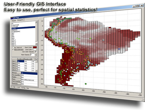
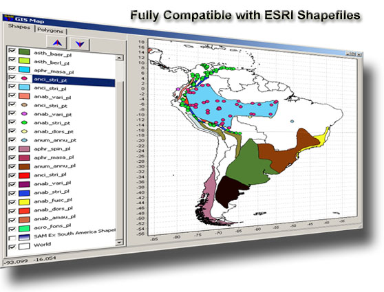
Take advantage of the GIS mapping module in SAM. It is the most user-friendly graphical interface for Geographic Information System ever designed in a spatial statistics software. SAM has now full compatibity with ESRI ShapeFile, by opening and saving data into this file format, and facilitating the interface with GIS softwares.
Mapping your data to visually explore the spatial structure. Mosaic or interpolated surfaces are available. Also, contour lines may be fitted to enhance the spatial pattern.
Use the new ďpattern finderĒ tool to select regions in the scatterplot and automatically highlight them in the map and in the spreadsheet. Of course, reverse direction is just as easy!
Easily create networks of connection among your sampling locations arbitrarily or according to several network criteria, like Delaunay Triangulation, Gabriel, Relative Neighbourhood, Minimum Spannin Tree, Distance Interval. Networks the become available for a wide range of spatial analyses in SAM.
If your variables violate the assumptions of the analysis of interest, you can try any of the several handy mathematical transformations available in SAM.
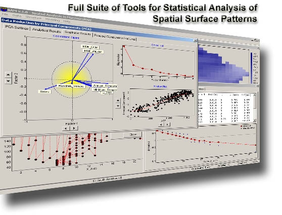
Reduce the dimensions of your data easily, synthesizing information into a few variables, avoiding collinearity and redundancy, using Principal Component Analysis (PCA).
Analyze the spatial structure in your data by means of autocorrelation coefficients, such as Moran's I and semi-variance.
SAM offers a very flexible tool that allows you to compute autocorrelation coefficient according to spatial distances (planar or geodesic) or network connectivity. Significance may also be tested by randomization procedures.
And if you are looking for Semi-Variance, this module is for your! You may compute and easily parameterize it according to eight different models.
However, if you are looking for fine spatial autocorrelation structure in your data, you may use and save the Local Indicator of Spatial Autocorrelation (LISA), based on Local Moran's I, which can be tested with randomization procedures.
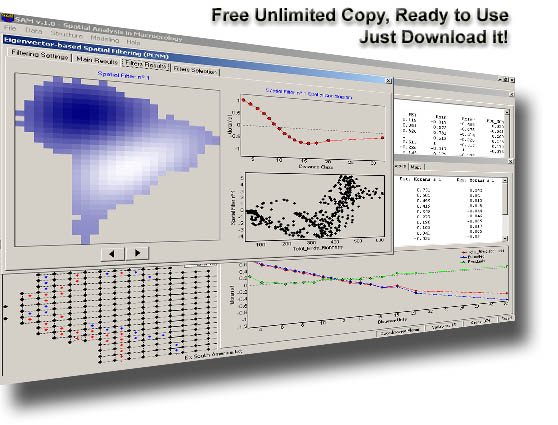
Filter broad-scale or small-scale spatial trends in your data using Trend Surface Analysis (TSA) or an Principal Coordinates of Neighbor Matrices spatial filter (PCNM, also known as "eigenvector-based" spatial filter).
Search for spatial outliers, scattering the values of a variable against the expected values according to spatial position.
Find the groups of observations that are similar by performing a cluster analysis with k-means procedure. Also, in SAM k-means can be spatially constrained, in order to find patches of similar observations contiguous in space.
Compute ordinary correlations among variables, and correct their significances estimating the correct number of degrees of freedom according to the magnitude of spatial autocorrelation.
Model a variable using SAM's highly intuitive graphical interface to perform Linear Regression Analysis. Check your model results, including the residual spatial autocorrelation and feel free to easily re-compute your model instantaneously. If you prefer, use Partial Regression to partition between the magnitudes of explanation due to your explanatory variables or to the spatial trend itself.
We are sure you will be thrilled by the new Model Selection and Multi-Model Inference module. Data exploration and model fitting was never so easy and intuitive. Just select potential explanatory variables and let SAM apply Akaike Information Criterion (AIC) to find the most parsimonious linear model. Easy as three clicks!
Want to study the geographical distribution of a species based on presence/absence data? Make sure you check the new Logistic Regression Module, which makes binary linear modeling extremely easy and intuitive.
It is easy to try several autoregressive models available in SAM. Estimate the autoregressive parameter and the magnitude of spatial autocorrelation by Pure Autoregressive Model available in the Lagged Models. Alternatively, filter response and predictor(s) variables, making sure that the results of your model are not influenced by spatial trends.
Try a straightforward, didactic and interactive two-steps Spatial Generalized Least Squares (spatial GLS, or kriging-regression).
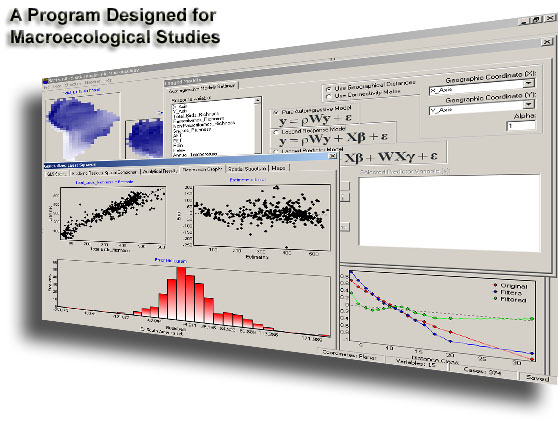
Model your data using well-known autoregressive models: Simultaneous Autoregressive Model (SAR), Conditional Autoregressive Model (CAR) or Moving-Average Model (MA).
If you have a reason to think that multiple spatially structured processes are driving your data, you should try the new Geographically Weighted Regression (GWR) module. Spatially explicit local regression was never so easy and fun! As usual in SAM all maps resulting from analysis will be under the reach of your mouse!